The 2011 Japan earthquake and tsunami was one of the most powerful natural disasters of the 21st century. On the afternoon of March 11, 2011, the ground began to shake across northeastern Japan.
At first, it seemed like another earthquake. In a country that experiences thousands of tremors each year, people are accustomed to the sudden rattling of buildings and the swaying of power lines.
But this one did not stop.
The shaking continued for nearly six minutes.
In coastal towns along the Pacific Ocean, people stepped outside, unsure of what was happening. Far away in Tokyo, hundreds of kilometers from the epicenter, office towers slowly swayed like trees in the wind.
What no one realized yet was that one of the most powerful earthquakes ever recorded in human history had just occurred beneath the Pacific Ocean.
The earthquake itself was only the beginning.
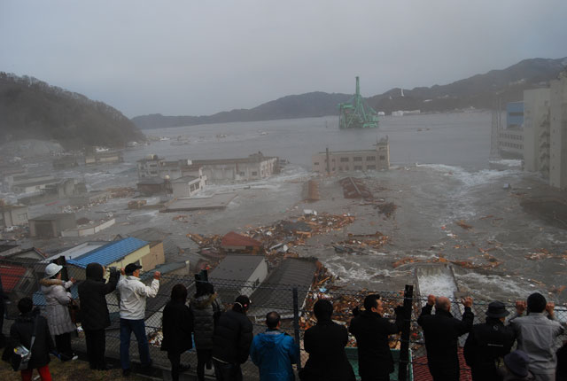
Within 30 to 40 minutes, enormous tsunami waves would reach the coastline of northeastern Japan, sweeping away towns, ports, and entire neighborhoods.
By the end of the day, more than 19,000 people had lost their lives, and thousands more were missing or displaced.
For those living far from earthquake zones, particularly in Europe, this disaster may feel distant. Yet in scale and impact, it was one of the most significant natural disasters of the 21st century.
To understand what happened that day, we must look beneath the ocean floor—and explore the immense geological forces that triggered it.
The Earthquake Beneath the Pacific
At 2:46 PM local time, a massive magnitude 9.0 earthquake struck off the northeastern coast of Japan.
The epicenter was located about 130 kilometers east of the Tohoku region, deep beneath the Pacific Ocean.
This earthquake occurred along a subduction zone, where one tectonic plate slowly slides beneath another. In this case, the Pacific Plate was pushing beneath the Okhotsk Plate, part of the larger North American Plate system.
For centuries, stress had been building along this boundary.
On March 11, that stress was suddenly released.
The seafloor shifted dramatically, lifting and dropping sections of the ocean floor by several meters. When such movement occurs beneath the sea, enormous volumes of water are displaced.
That displacement creates what we know as a tsunami.
Unlike ordinary waves created by wind, tsunami waves involve the movement of the entire water column—from the ocean surface all the way down to the seabed.
Once generated, these waves travel across the ocean at extraordinary speeds, sometimes exceeding 700 kilometers per hour in deep water.
But when they approach shallow coastal areas, something dramatic happens.
The wave slows down.
And as it slows, the water rises.
How Powerful Was a Magnitude 9.0 Earthquake?
To understand the scale of the disaster, it helps to understand how earthquake magnitude works.
The magnitude scale is logarithmic. This means each whole number increase represents a dramatic increase in energy.
A magnitude 9.0 earthquake releases:
- about 32 times more energy than a magnitude 8.0
- nearly 1,000 times more energy than a magnitude 7.0
The 2011 earthquake was the largest ever recorded in Japan.
According to the U.S. Geological Survey, it was also the fourth largest earthquake recorded anywhere in the world since 1900.
To place this in a European context:
- 2009 L'Aquila earthquake (Italy): Magnitude 6.3
- 1999 Athens earthquake (Greece): Magnitude 5.9
- 1908 Messina earthquake (Italy): estimated magnitude 7.1–7.2
Even the devastating Messina earthquake—one of the deadliest in European history—was far smaller in magnitude than the 2011 earthquake in Japan.
The difference in energy released was enormous.
But the earthquake alone was not responsible for most of the destruction.
That devastation came from the sea.
Why the Tsunami Became So Destructive
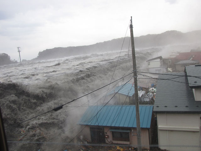
The tsunami that followed the earthquake struck Japan’s northeastern coast with extraordinary force.
In some areas, waves reached heights of more than 15 meters, while in others they surged far inland.
In certain narrow valleys, the tsunami reached run-up heights approaching 40 meters.
To visualize this, imagine a wall of water as tall as a 10-story building moving inland.
Several factors contributed to the tsunami’s destructive power.
The Role of Geography
The coastlines of Iwate and Miyagi Prefectures are famous for their dramatic natural beauty.
This region is known as the Sanriku Coast, characterized by a geographical formation called a ria coastline.
A ria coastline forms when seawater floods river valleys in mountainous terrain, creating a landscape of narrow bays and steep inlets.
While this geography creates spectacular scenery, it also has a dangerous characteristic.
It can amplify tsunami waves.
When a tsunami enters a narrowing bay:
- the water becomes compressed
- wave height increases
- the force pushing inland intensifies
In several locations along the Sanriku Coast, this natural amplification significantly increased the tsunami’s destructive power.
.jpg)
Japan: A Nation Prepared for Disasters
Japan is one of the most earthquake-prone countries in the world.
Approximately 18.5% of all earthquakes of magnitude 6 or greater occur in Japan.
Because of this constant threat, Japan has developed some of the most advanced disaster preparedness systems in the world.
These include:
- earthquake-resistant building design
- nationwide early warning systems
- tsunami alert networks
- coastal seawalls and protective structures
- regular evacuation drills in schools and communities
Given these measures, a natural question arises:
Why were so many lives still lost?
When the Disaster Exceeded Expectations
One of the main reasons was that the tsunami exceeded design assumptions.
Many coastal seawalls had been built based on historical tsunami data.
But the waves generated by the 2011 earthquake were far larger than those expected by existing models.
In several towns, tsunami waves overtopped or destroyed seawalls.
The disaster sparked intense debate in Japan around the phrase “beyond assumptions.”
For many people outside Japan, this phrase sounded like an excuse.
But in reality, it reflected the limits of prediction.
Even in a country deeply experienced with earthquakes and tsunamis, the scale of this event surpassed modern planning scenarios.
Nature had exceeded what experts believed possible.
The Human Factor
Another factor was demographic.
Many fishing communities along the Tohoku coast have aging populations.
Evacuating from a tsunami requires speed. In many places, residents must reach higher ground within minutes.
For elderly residents, this is not always easy.
Steep roads, limited mobility, and confusion during emergencies can make evacuation difficult.
These human realities played a role in the tragic outcome.
The Story of the Minamisanriku Disaster Management Center
Among the many stories from the disaster, one location became a powerful symbol of courage and sacrifice.
In the coastal town of Minamisanriku, officials had taken tsunami preparedness seriously for decades.
After the 1960 Chile earthquake, which generated a tsunami that also reached Japan, the town strengthened its disaster planning.
At the center of this system stood the Minamisanriku Disaster Management Center—a steel building about 12 meters high, designed to coordinate emergency responses.
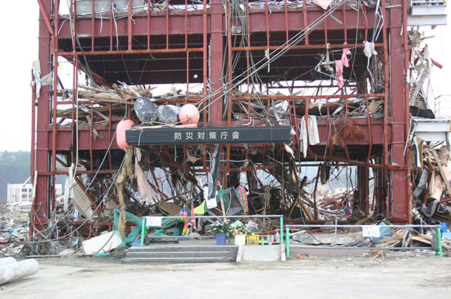
On March 11, about 30 municipal employees were working inside the building when the earthquake struck.
As tsunami warnings were issued, staff members began broadcasting evacuation instructions through loudspeakers.
Even as the water approached, they continued urging residents to flee to higher ground.
Among them was a young female employee who repeatedly broadcast evacuation messages as the tsunami closed in.
When the waves reached the town, the staff climbed to the rooftop and clung to antennas and railings.
But the tsunami that struck the building reached 15.5 meters.
The waves engulfed the structure.
In total, 43 people on the rooftop lost their lives, including 33 town employees.
Many of those who died were disaster response officials who had remained behind to help others escape.
One survivor later recalled the moment after the first wave passed and he realized many of his colleagues had disappeared.
He described it simply as:
“An indescribable sense of despair.”
Today, the skeletal remains of the building still stand.
There was debate after the disaster about whether the structure should be demolished.
In the end, the town chose to preserve it.
Minamisanriku chose memory over erasure.
The building stands today not as a spectacle, but as a testimony.
When Minutes Decide Survival
In the same town, a woman who ran a small guesthouse on a hill overlooking the harbor felt the violent shaking and sensed something was wrong.
Her husband initially planned to go down to the port to secure their fishing boat.
But she stopped him.
Instead, they evacuated immediately to higher ground.
Soon after, the water in the bay began to withdraw dramatically, exposing the seabed.
Eight minutes later, the tsunami arrived.
The wave crashed into the mountains at the end of the bay, rebounded, and merged with the following wave.
The combined force drove water nearly 20 meters above sea level, sweeping away homes near the harbor.
Waves returned again and again.
Buildings were destroyed.
Entire neighborhoods disappeared.
Another survivor later described how the tsunami did not appear as a crashing wave from above.
Instead, the sea itself seemed to rise and surge forward, filling the land.
In tsunami disasters, survival often depends on one decision:
How quickly do people evacuate?
Studies after the disaster showed that those who began evacuation within 20 minutes of the earthquake had a far higher chance of survival.
Many survivors later said they fled immediately after feeling the earthquake—without waiting for official warnings.
Understanding the Scale
The physical scale of the disaster is difficult to comprehend.
At its peak:
- tsunami run-up heights reached around 40 meters in some locations
- waves reached the coastline 30 to 40 minutes after the earthquake
- hundreds of square kilometers of land were flooded
To imagine such a scenario in Europe, picture a 15-meter wall of water striking:
- a harbor town in southern Italy
- a fishing village in Greece
- a seaside promenade along the Mediterranean coast
Boats would be carried inland.
Cars overturned.
Concrete buildings reduced to skeletal frames.
It is a scale that is difficult to imagine until it happens.
Yet the story of the Sanriku Coast did not end with destruction. In the years that followed, communities across the region began the long process of rebuilding their towns and their lives.
Minamisanriku Sun Sun Shopping Village: A Symbol of Resilience
After the tsunami destroyed much of the town center, local shop owners faced an uncertain future. Many businesses had been washed away, and residents had lost not only homes but also their livelihoods.
In response, local entrepreneurs came together to rebuild their commercial community.
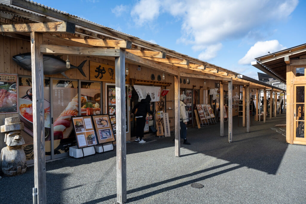
In 2012, they opened a temporary marketplace called Minamisanriku Sun Sun Shopping Village (Minamisanriku Sun Sun Shōtengai). The name “Sun Sun” expresses brightness and hope—like sunlight returning after a storm.
The shopping area was originally built using colorful temporary structures, creating a lively and welcoming atmosphere even while reconstruction was still underway.
Over time, the market became more than just a place to shop.
It became a symbol of local resilience.
Visitors from across Japan—and from around the world—began traveling to Minamisanriku to support the town’s recovery. The shopping village offered fresh seafood, regional specialties, and handmade products from the Sanriku coast.
In 2017, a new permanent version of the shopping village opened on higher ground, designed with traditional wooden architecture inspired by the region’s fishing culture.
Today, the market stands as a reminder that recovery is not only about rebuilding structures, but also about restoring community, livelihoods, and hope. Rebuilding a town also means remembering what happened there.
Remembering and Moving Forward
Walking through Minamisanriku today, visitors can see both memory and renewal.
The skeletal remains of the Disaster Management Center still stand as a memorial to those who lost their lives while helping others escape.
Nearby, the lively atmosphere of the Sun Sun Shopping Village reflects the determination of residents who chose to rebuild their town rather than abandon it.
These two places—one a memorial, the other a marketplace—tell a shared story.
They remind us that even after immense tragedy, communities can find ways to move forward.
The recovery of the Sanriku Coast is still ongoing. Yet the spirit of the region continues to shine through its people, its culture, and its connection to the sea.
If You Visit the Sanriku Coast Today
Today, many visitors who travel along the Sanriku Coast come not only to remember the disaster, but also to support the communities that have rebuilt their lives. Visitors to the Sanriku Coast encounter a landscape of dramatic beauty.
Steep cliffs meet the Pacific Ocean, fishing boats return to quiet harbors, and small coastal towns continue traditions that have existed for generations. The region is known for its fresh seafood, rugged coastline, and deep connection to the sea.
Yet beneath this peaceful scenery lies a powerful history.
Throughout the Sanriku region, visitors can find memorial parks, preserved disaster sites, and museums that tell the story of the 2011 earthquake and tsunami. These places are not designed to shock or overwhelm visitors, but rather to help people understand what happened and why the memory remains important.
At the same time, daily life has returned.
In towns like Minamisanriku, local markets such as the Sun Sun Shopping Village welcome visitors with seafood, regional specialties, and warm hospitality. Fishermen continue to work the waters of the Pacific, and new generations are growing up in communities that have rebuilt themselves with remarkable determination.
For many visitors, traveling to Sanriku is more than a sightseeing trip.
It becomes a way to learn about resilience, community, and the relationship between people and nature.
Supporting local businesses, visiting memorials, and simply listening to the stories of the region all contribute to keeping the memory of the disaster alive while helping communities move forward.
A Coast of Memory and Hope
The Sanriku Coast today tells two stories at once.
One is a story of tragedy—a reminder of the immense power of nature and the lives lost on March 11, 2011.
The other is a story of resilience.
Across the region, towns have rebuilt their ports, communities have restored their livelihoods, and visitors continue to learn about history and support the people who live there.
The ocean that once brought destruction is also the ocean that has sustained these communities for centuries.
And along the Sanriku Coast, the people who call this place home continue to live with that reality—with respect, memory, and hope for the future.
A Lesson Beyond Japan
The Great East Japan Earthquake and Tsunami was not only a tragedy for Japan.
It was a reminder of the immense geological forces that shape our planet.
The event also highlighted both the strengths and limits of disaster preparedness.
Even the most advanced systems cannot eliminate risk entirely.
But understanding disasters, learning from them—can help societies become more resilient.
At JLPS, our mission is not only to introduce Japanese culture and traditions, but also to deepen understanding of Japan itself.
And to understand Japan is to understand its relationship with nature.
A relationship shaped by respect, preparedness, and humility in the face of forces greater than ourselves. For the communities along the Sanriku Coast, the events of that day are not distant history, but a memory that continues to shape everyday life. Fifteen years later, the memory of March 11 remains an important reminder—not only for Japan, but for the world.